By Asta Mail,
Marine conservation student
Imagine that you are entrusted with the duty of conserving a colony of beautiful seabirds. Your objective is to create Marine Protected Areas (MPA’s) that shelter birds from disturbances, so that they can do what they do best: eat, sleep, fly and reproduce! How then do you decide which marine areas are the most important to protect?
According to a recent paper by Caphuysen et al. (2012), MPAs are the most effective if they are “guided by at least some understanding of the natural history and habitat requirements of seabirds.” Traditionally, bird population dynamics have been studied using boat-based observational data collection. Surveys look for the presence or absence of birds within particular areas, and the number of birds seen in certain locations over time. “Large amounts of data have been collected to assess distribution patterns of seabirds around the world” (Caphuysen et al. 2012), and areas of high bird abundance have been noted in distribution maps. However, there has been an absence of behavioral information related to bird distribution, and the ecological significance of areas where birds congregate is not well understood.
Camphuysen et al. (2012) sought to collect information on the behaviors of birds at sea, so that they could understand why birds congregate in some areas and not in others. Having an idea of what birds are doing in particular areas is “crucially important” in selection of areas for protection, and “could lead to more precise delineations of areas of ecological importance” (Camphuysen et al. 2012).
This research is focused on two important European sea bird species, the Northern Gannet (Morus Bassanus) and the Lesser Black-backed Gull (Larus Fuscus). The authors compiled 20+ years worth of observational data to create distribution patterns around the roosting areas of distinct populations of each species.
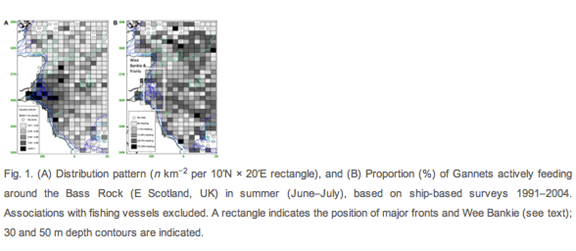
Figure 1 from Camphuysen et al. 2012
To gain insight into the bird’s behaviors while at sea, Campuhysen et al.’s research team then took advantage of the development of STT satellite tags. Tags were deployed on select birds from each species and target population, and data was collected which related to individual bird behavior. The tags provided GPS tracking coordinates, as well as the bird’s speed, temperature, altitude, and location in real time, along with environmental measurements. This information was used to interpolate behaviors, such as “where the bird is going, how long it spends in different places and what it is (likely) doing” (Campuhysen et al 2012).
Camphuysen et al. (2012) theorized that combining the behavioral information from satellite tags with their survey based observational data would allow “ a quantitative analysis of (potential) feeding areas at sea” to be created. Foraging behavior would be the most valuable behavior to protect, and therefore MPA’s would be most effective in areas where birds regularly congregate to feed and forage.
The results of the combined methodologies appeared to be promising, if not yet well analyzed. Both types of data collected were in agreement about the foraging ranges of the selected species but “information on the feeding activities of birds would require a more integrated analysis… to reach firm conclusions”(Camphuysen et al. 2012). The paper notes that for both bird species, areas that were important in survey data alone were different than areas of importance when looking at both density and behavior data. The authors conclude that the combination of observational and tagging data could potentially lead to “ different and certainly more precise conservation proposals or management decisions” (Camphuysen et al. 2012).
This new methodology may help to shed light on what behaviors are observed within particularly high density areas. However, I would conclude that Camphuysen et al.’s methodology is missing some important variables that would be significant in understanding foraging behavior and population density. I would be hesitant to use this methodology to select Protected Areas, as it does not properly take into account the most important factor in foraging: prey dispersal.
Camphuysen et al. (2012)’s paper notes that “information on key issues such as prey availability” is lacking. Given that marine environments are constantly changing, it would be a challenge to study prey abundance through observational research. However, by considering variables such as regional current flow, areas of high seasonal primary production, and the presence or absence of other marine predators that eat similar prey, perhaps estimates of prey concentration could be added to the analysis. If prey availability, foraging behavior and population density all combined in the same specific areas, I believe you could confidently define those areas for protection.
When choosing a Marine Protected Area, I think it would be relevant to consider the population densities of birds, but also that of the marine life living around them. It could be wise to take into account the population densities of marine mammals, for example, or perhaps other bird species. MPA’s could be also be designed to take into account other ecologically important values, such as locations where upwelling occurs, or where particularly important bottom structures are found, such as sea mounts, or seagrass beds. Human use of marine areas should always an important factor in the creation of Marine Protected areas, particularly when birds are feeding near or on important fishing grounds.
Satellite tagging technology has evolved very quickly, and more information can be gained from new tagging techniques now than ever before (Patterson et al. 2008). Perhaps in future research, avian tags could be designed to provide more accurate readings of the environmental conditions, such as surface water temperature, water clarity, or wind direction and speed. This might help explain why birds congregate in certain areas, based on their preferences for certain conditions.
Attachable video cameras, like the ones used with Northern Gannets in this video (hyperlink http://www.youtube.com/watch?v=ix24ppTHMGE) could also be incorporated into the methodology, to help see if other birds are present where tagged birds are foraging, or to see in real time what the birds really do while away from their roosting grounds.
While new methodology may contribute to the ecological understanding of avian behavior, I believe that more diverse ecological and environmental data should be considered in the process of developing precise and useful MPA’s. Perhaps a better understanding of the ecological processes that support bird populations should first be considered, so that the foraging behaviors of bird populations will be protected, as well as the ecosystems they rely on.
REFERENCES
Campuhysen K, Sharmoun-Baranes J., Bouten W. and Garthe S.Identifying Ecologically Important Marine Areas for Seabirds Using Behavioral Information in Combination with Distribution Patterns. Biol.Conserv. (2012).
Patterson T, Thomas L,Wilcox C, Ovaskainen O, and Matthiopoulos J.State–space models of individual animal movement. Trends in Ecology & Evolution (2008),Vol 23: pp 87–94
Nils Holgerson Cruising on the Back of a Northern Gannet. Youtube video uploaded by user speafame. http://www.youtube.com/watch?v=ix24ppTHMGE


Leave a Reply
Want to join the discussion?Feel free to contribute!