A simple tool to predict bycatch in harbour porpoises
By Emily Nelson, SRC master’s student
Harbour porpoise bycatch has been identified as the biggest threat facing these animals in many areas today, with many incidental catches occurring in large commercial gillnet fisheries. In efforts to minimize negative impacts, harbour porpoises in waters of the European Union have been awarded protection under Habitats Directive (EC 1992) and Council Regulation 812/2004 (EC 2004). Despite differences in specifics, these policies both work towards conservation and would benefit from increased information regarding bycatch of porpoises.

Harbour porpoise in Denmark. Photo by Erik Christensen.
Kindt-Larsen et al. 2016 aims to create a model that can identify areas and seasons where porpoises are at high risk of entanglement in commercial fishing gear. Two main high-resolution datasets were used to develop the model. First, fisheries and bycatch data was obtained from remote electronic monitoring systems aboard 4 commercial gillnet operations in the Danish part of the Skagerrak Sea. Using video footage of gillnet hauls the authors were able to identify time and location of harbour porpoise bycatch events. Fishing effort (defined as the product of gillnet string length and net soak time), fishing target species (cod, plaice, and hake), and season (winter, spring, summer, and autumn) were also used. Second, estimated population density of harbour porpoises was obtained using satellite tag data from 66 individuals in the same area. Data was filtered to remove positions that may be inaccurate, such as locations that required excessively high swim speed to reach. Further, tag data was manipulated according to a grid system. A value was assigned to each 1km grid cell within the study area reflecting the likelihood the particular cell was visited by harbour porpoises.
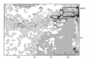
Density of harbour porpoises, estimated from satellite tagging data using a grid system.
This data was then used to identify the general relationship between expected bycatch and porpoise density. The authors started with the most complex model (involving all variables) and sequentially removed insignificant variables in order to find the best fit. In the end, target species and length of net did not improve the model fit. Additionally, porpoise density estimated using season and area (rather than satellite tag data) did not improve fit. The best model was very simple; harbour porpoise bycatch was best explained using solely soak time of fishing gear and satellite tag estimates of population density.
The success of the model developed by Kindt-Larsen and colleagues relies on a few large assumptions. First, the assumptions that satellite tagged porpoises are representative of the population as a whole. This concern was addressed in a number of ways. 1. Analysis was run showing that the spatial patterns observed were consistent over time. 2. Areas of high density predicted by satellite data were verified because acoustic surveys show similar results. 3.The satellite tagged individuals contained a mixture of juvenile, adult, male and females, thus there is no bias in the data do the demographic differences. The second assumption is that fishing effort estimations are truly representative of the four fisheries. This is verified because fishing effort was calculated the same way throughout all vessels. Lastly, the assumption that recorded porpoise bycatch was representative of the true number of bycaught animals. This assumption was of little concern to the authors because the REM video was of high quality and bycatch was easy to identify. However, if porpoises fell from the net prior to reaching the surface they were not recorded. For this reason it is important to consider bycatch estimates presented here as a minimum. Overall, it seems the assumptions of the model will have minimal impact on results.
The model created by Kindt-Larsen and colleagues follows the simple principle, that bycatch can occur only if the animal and fishery have an overlap in space and time. While the model presented is basic, it can absolutely act as a starting point for investigations of harbour porpoise bycatch. Results will be able to identify regions and/or seasons of high and low risk to porpoises. This will aid in future bycatch monitoring and the development of mitigation strategies.
Works cited
EC (European Commission) (1992) Habitats Directive: Council Directive 92/43/EEC of 21 May 1992 on the conservation of natural habitats and of wild fauna and flora. Off J Eur Union L 206: 7−50
EC (2004) Council Regulation (EC) No. 812/2004 of 26 April 2004 laying down measures concerning incidental catches of cetaceans in fisheries and amending Regulation (EC) No. 88/98. Off J Eur Union L 150: 12−31
Kindt-Larsen, L., Berg, C.W., Tougaard, J., Sorenson, T.K., Geitner, K., Northridge, S., Sveegaard, S., & Larsen, F. (2016). Identification of high-risk areas for harbour porpoise Phocoena phocoena bycatch using remote electronic monitoring and satellite telemetry data. Marine Ecology Progress Series, 555, 261-271.