Posts

A spatiotemporal long-term assessment on the ecological response of reef communities in a Caribbean marine protected area

By: Megan Ando, SRC intern.

Marine Protected Areas (MPAs) have played a large role in the maintenance and conservation of vital marine ecosystems and species, many of which are endangered due to anthropogenic and natural causes. They also provide an ideal setting in which to perform long-term monitoring studies in order to analyze trends in coral reef communities, which provide a vast amount of insight into an ecosystem’s resilience. A compiled study, carried out over the course of 11 years by Martínez-Rendis et al., set out to observe one of these MPAs in hopes of assessing both the spatial and temporal long-term trends of some of the coral reef community indicators, which can be essential when it comes to mitigating and adapting to the several consequences of ecological shifts (Ricart et al., 2018). Being carried out in Cozumel, Mexico, studies like this are vital due to the recently recorded rapid degradation of coral reefs that are proven to be so important for the well-being of our planet (Mora, Graham, & Nyström, 2016). There have only ever been a few studies carried out in the Caribbean that provide time sequences and indicators of these systems, so studies like this provide the scientific community, and the world, with a great array of knowledge concerning the resilience of such a natural protected area.

As previously mentioned, this study took place in Cozumel, Mexico along six different reefs, all within different “zones” contained in the Cozumel Reefs National Park (CRNP) (Figure 1). These zones vary in their restrictions regarding fishing, scuba-diving, cruise ships, and other tourist activities that attract so many people to this reef system from around the world. The sampling performed in this area was executed through the use of transects, along which coral species, fauna densities, and other important details about the surrounding area were all recorded. The aforementioned indicators were also taken note of, which included densities of fish species, densities of trophic groups, species richness for each trophic group, relative cover of all scleractinian coral, and the corresponding relative coverage of macroalgae. Each of these indicators were eventually used in order to identify fish trophic groups with trends pertaining to the CRNP coral reef ecosystem, each of which would then infer information about the overall resilience of the MPA for future ecological conservation implications (Martínez-Rendis et al 2019). Such trophic groups have been used in the past to describe how fishing pressures affect reef trophic dynamics (Darling & D’Agata, 2017). Statistical tests were performed with all of this data to conclude their results.

Overall, it was found that differences in fish species appeared to be associated with distributions of the dominant species over the reef system, being controlled ultimately by environmental dynamics (Díaz-Ruiz, Aguirre-León, & Arias-González, 1998). Also, the changes seen in the densities of the fish trophic groups were both temporal and spatial, suggesting that both natural effects, including storms and hurricanes, and anthropogenic events, meaning construction and coastal development, cause changes in the abundance of these reef communities. As far as coral cover, there appeared to be a direct relationship between coral cover and corresponding macroalgae cover (Figure 2). Such algae cover could be promoted by an increase in coastal sediment discharge or other cumulative anthropogenic effects, which has the potential to surround and kill healthy coral.

To conclude, this group drew key conclusions regarding ecological trends and relevant constructive information that can be used to restructure the MPA for its own benefit as well as the benefit of the natural reef systems and all living organisms that it supports. It provides motivation for the further exploration of proper management strategies that need to be in respect to the tourists as well as the marine organisms in order to better conserve this reef system for generations to come.

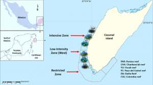
Figure 1: Map showing location of Cozumel off of the Mexican coastline, as well as the various reefs and zones being studied within the CRNP (Martínez-Rendis et al 2019).


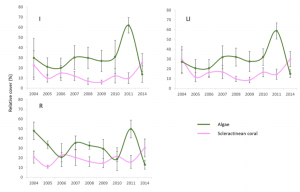
Figure 2: Graphic visual showing the direct trends in relative cover of scleractinian coral (purple) versus macroalgae (green) within the CRNP (Martínez-Rendis et al 2019).


Works cited

Darling, E. S., & D’agata, S. (2017). Coral. Reefs: Fishing for Sustainability. Current Biology.

Díaz-Ruiz, S., Aguirre-León, A., & Arias-González, J. E. (1998). Habitat interdependence in coral reef ecosystems: A case study in a Mexican Caribbean reef. Aquatic Ecosystem Health & Management, 1, 387–397.

Martínez-Rendis, Abigail, et al. (2019). A spatio-temporal long-term assessment on the ecological response of reef communities in a caribbean marine protected area. Aquatic Conservation: Marine and Freshwater Ecosystems, 30, 2, 273–289.

Mora, C., Graham, N. A. J., & Nyström, M. (2016). Ecological limitations to the resilience of coral reefs. Coral Reefs, 35, 1271–1280.

Ricart, A. M., García, M., Weitzmann, B., Linares, C., Hereu, B., & Ballesteros, E. (2018). Long-term shifts in the north western Mediterranean coastal seascape: The habitat-forming seaweed Codium vermilara. Marine Pollution Bulletin, 127, 334–341.

Shifted Baselines Reduce Willingness to Pay for Conservation

By Molly Rickles, SRC intern

With climate change causing negative consequences for almost every ecosystem on earth, now it is more important than ever to fund conservation efforts to restore these extremely important environments. However, many people are unaware about the current state of these critical environments, which may affect their willingness to contribute to these important causes.

In this article, McClenachan et al. (2018) studied whether an individual’s willingness to pay for conservation efforts was affected by their perception of the current health of the environment, which is generally an understudied topic. The researchers used the concept of shifted baselines, or a reduction in expectations of the natural environment over time, to determine if people’s perception of the state of the environment was flawed. It has been previously stated that the public does not understand the baseline for coral reef health, which means that they have no comparison to today’s reefs. This is important to understand for conservation efforts, so that researchers can understand how the public gets engaged in these issues.

To answer their questions, the researchers conducted a survey of residents in Okinawa, Japan, to determine how they viewed change in coral reef ecosystems. It was found that respondents understood that there was a decline in coral reef health, but that the reasons for this decline were unknown. 67% of respondents were able to identify at least one component of decreased health of coral reefs. It was also found that respondents were more willing to pay for the creation of an MPA to solve these problems rather than donating to other conservation efforts, with the average donation being $142.22 annually. (Image 1) The researchers concluded that shifted baselines for reef health did affect willingness to pay for conservation, and that respondents that perceived a decline in reef health were willing to pay more than double than someone who did not understand this decline in health. This research shows the importance of documenting long-term change in ecosystem health, so that the results can be communicated to engage the public in these issues. With a stronger public engagement, people will be more willing to contribute to conservation efforts, which will help raise awareness and funds for these extremely important issues.

Image 1. This table shows how willingness to pay varies for different problems associated with declining reef health. Respondents had the highest willingness to pay for the creation of an MPA (Source: McClenachan et al. 2018)

Image 2. This graph shows the difference between willingness to pay when respondents understand that there are declines in ecosystem health versus when they believe the current state of the ecosystem is normal (Source: McClenachan et al. 2018).


Works Cited

McClenachan, L., Matsuura, R., Shah, P., & Dissanayake, S. T. (2018). Shifted Baselines Reduce Willingness to Pay for Conservation. Frontiers in Marine Science , 5. doi:10.3389/fmars.2018.00048

The need for MPAs in the Antarctic

By Haley Kilgour, SRC Intern

With global climate change in effect the Arctic ice sheet has been losing area and has gone from 7.5 million km^2 in 1979 to 4 million km^2 in 2016 (Figure 1). The loss of ice coverage is detrimental to many species, but on the other hand opens up areas to new fishing grounds, oil and gas deposits, deep sea minerals, and shorter shipping routes that were previously inaccessible. While economically it is beneficial to exploit these now accessible resources, it is also necessary to designate Marine Protected Areas (MPAs) to preserve habitat and biodiversity.

Figure 1

Year round see ice cover for the periods of 1979-1984 and 2012-2016.

Geomorphic features such as seamounts, submarine canyons, hydrothermal vents, submarine plateaus, ridges, and escarpments serve as a proxy for benthic communities and ecological processes as they are often areas of high biodiversity and important to processes such as upwelling. Harris et al looked at the distribution of geomorphic features on the sea floor to assess their current level of protection within MPAs. They also aimed to see if these features were occurring within or outside of MPAs and identify ones that were once inaccessible due to year round sea ice.

To determine their area of study, Harris et al used the average minimum sea ice coverage from 1979-1983. They looked at the years 1979-1983 and 2012-2016 (the earliest and latest time periods) to see how much of the geomorphic features are now exposed. Twenty-nine categories of features were mapped using Shuttle Radar Topography Mapping (Shuttle Radar Topography) and MPA boundaries were taken from the IUCN and UNEP-WCMC database. The program ArcGIS was then used to compute areas.

On average, 31% of all previously year round covered features in the Arctic are now in open water in September. In 1979-1983, only 2.33% of areas below year round sea ice were in MPAs, and these were mostly areas on coastal and shelf habitats (Figure 2). This lack of diversity in features that are protected means there is high potential for them to be exploited now that year round ice no longer prevents access.

Figure 2

MPAs within the Arctic in relation to September sea ice cover in the periods 1979-1983 and 2012-2016.

As it stands, only 2.3% of the areas used in this study are in MPAs. While this seems to pose a problem, Canada, Denmark, Russia, Norway, and the USA have signed a “Declaration concerning the regulation of unregulated high seas fishing in the central Arctic Ocean” and a moratorium. Thereby, the areas beyond national jurisdiction have a degree of protection from fishing pressure at the current time.

Current MPAs mostly cover coastlines and inner shelf regions. Abyssal plains are not covered at all and there negligible protection for slope habitats. While the current MPAs do provide a small effect, they are not representative in the standard MPA design.

There are many geomorphic features that have been left exposed and all are fragile ecosystems. Basins collect sediment and anthropogenic contaminants, making them particularly susceptible to pollution from runoff and chemicals. Submarine canyons are considered biodiversity hot spots and prime fishing grounds, making them vulnerable to degradation. Only .2% of canyons are within existing MPAs and retreating sea ice now exposes 37% of their area. Submarine canyons face particular danger because they are associated with oil and gas deposits. Plateaus are mostly unexplored worldwide and thus need further examination and protection.

These underwater geomorphic regions are high in biodiversity but are finding themselves in peril with retreating sea ice. Many of these areas are likely under rapid ecological transition as the Arctic responds to global climate change. These ecosystems are highly unexplored and sensitive. They could be lucrative economically, but are also most likely highly important for conservation. MPAs will play a major role in protecting these areas.

Global Review of Social Indicators used in Protected Area Management Evaluation

By Josh Ratay, SRC Intern

Figure 1

Global map of the world’s protected areas. These areas are numerous and often require a great deal of management assessment, in which social indicators play a large role. Image from University of Maryland, Baltimore County, using data from the United Nations Environment Programme.

Although conservation deals heavily with environmental data, social aspects of conservation initiatives are also extremely important. When human-related considerations are taken into account, certain trade-offs must often be made, but the end result is usually more effective at fulfilling the goals of the project, particularly at the local level. In a recent study, researchers examined the social aspects of protected areas around the world, relating social indicators and well-being dimensions. These went beyond simple measures of wealth and included education, healthcare, government, and social unity.

A pre-existing database, the Global Protected Area Management Effectiveness Database (GDPAME), which contains records of assessments made at different protected areas around the world. It contains information about both social and environmental factors and is used by policymakers as a source of information. For the study, social indicators were any factors that were placed in the context of local/indigenous affairs. Multiple existing frameworks were used to analyze indices of well-being. Indicators were examined in different scenarios, and classified as positive, negative or neutral. Differing methodologies for assessing protected areas very greatly in the number of indicators used, ranging from 13 to 429. The percentage of indicators relating to social issues also vary greatly, with a minimum of 7% and a maximum of 60%. Interestingly, the methodology which used 60% social indicators was exclusively for marine protected areas (“How is Your MPA Doing?”).

Figure 2

“How is Your MPA Doing?”, a manual released as a collaboration between NOAA, WWF, the IUCN and others, serves as a method for evaluating MPAs which focuses heavily on social indicators.

The study found that the most common dimension of well-being to be taken into account was living standards. Security and culture were also high-ranking. Overall, about one quarter of all indicators were social, showing that conservation management is increasingly taking social considerations into account. However, the study did recommend additional actions that should be taken to further increase coverage. Firstly, it proposed greater focus on community dynamics, as opposed to purely physical measurements such as resource availability. Additionally, many of the indicators focused heavily on the state of a conservation project after its implementation, and put less emphasis on local engagement during the early phases of an initiative. Changing this could better promote community participation by involving locals in the building of a policy, instead of only the continued management of existing policies. Additionally, the cultural values of a given area should be given increased consideration. The study also noted the bias toward describing environmental impacts of human initiatives as negative, and recommended that more specific language be used for future indicators. Overall, this review of social indicators and well-being dimensions showed the importance of integrating local communities in both the planning and assessment methods of protected areas to improve the effectiveness of conservation initiatives.

Work Cited
Corrigan, Colleen, et al. 2016. “Global Review of Social Indicators used in Protected Area Management Evaluation.” Conservation Letters.

Marine protected area help recover fish without harming fishers

by Kyra Hartog, RJD Intern

With fisheries collapsing around the world, Marine Protected Areas (MPAs) have emerged as a potential solution to allow fish stocks to recover to a level at which they may be harvested sustainably. There are several types of MPAs, ranging from areas with some fishing allowed to no-take reserves. Though MPAs are widely considered as fishery recovery tools, there has been little empirical evidence showing the benefit a fishery may receive from an MPA. In addition, fishermen generally believe that an MPA will come with an economic cost, possibly related to decreased catch rates and increased boat travel time. In their recent paper, Kerwath et. al (2010) demonstrate the effectiveness of the no-take Goukamma MPA off the coast of South Africa with no apparent cost to fishermen.

The focus species of this study was the roman (Chrysoblephus laticeps), a seabream endemic to the South coast of South Africa that inhabits rocky reefs. The species is targeted as part of a larger fishery directed toward rocky-reef dwelling predatory fish. Due to lifestyle characteristics such as long lifespan and broadcast spawning reproduction, the roman is vulnerable to overexploitation and has been heavily depleted along the South African coast. Fishermen have been required to report species and boat catch data since 1985, providing five years of roman catch data before the Goukamma MPA was implemented in 1990. The study then examined catch data for ten years following the MPA’s implementation. The specific metrics used in this study were catch per unit effort (CPUE), which was used as an indicator for roman abundance, and total roman catch.

The researchers found that in the years leading up to and during the first year of the Goukamma MPA implementation (1985-1991), total roman catch decreased. A year after the MPA was implemented, roman catch began to increase. While there was no visible trend in CPUE before the MPA, researchers saw an increase in CPUE in the vicinity of the MPA after its implementation. Other areas further away from the Goukamma MPA exhibited neither positive nor negative effects with respect to CPUE or total catch. The researchers also did not see any increased travel time for fishermen due to the availability of access points to the fishery outside of the MPA.

Figure 1 from Kerwath et al. 2013

Figure 1 from Kerwath et al. 2013

The analysis of fishery data suggests to the researchers that the Goukamma MPA was effective in terms of fishery management and conservation of the roman. Though the exact reasons as to why the MPA was effective have not been investigated, it is believed that spillover and larval export from the MPA are the main contributors to the increase in CPUE around the MPA. When roman inside the MPA are protected, the biomass of the species will increase inside the area until the species has recovered sufficiently. Spillover of adults will occur, as the fish are able to grow without pressure from fishing. After males and females have recovered to pre-exploitation numbers, further CPUE increases can be attributed to recruitment of larval roman. The currents in the area can allow pelagic larvae to stay in the area of the MPA, where they can then settle out, grow and become available to the fishery.

This study gives strong positive evidence for MPA use as a fishery management tool. It provides empirical evidence for fishery recovery without great cost to the local fishermen. This study can be cited as reason to implement MPAs in areas around the world where species similar to the roman are in decline due to exploitation.


REFERENCE

Kerwath, S. E., Winker, H., Götz, A., & Attwood, C. G. (2013). Marine protected area improves yield without disadvantaging fishers. Nature Communications, 4, 1–6. doi:10.1038/ncomms3347


Do birds of a feather forage together?

By Asta Mail,
Marine conservation student

Imagine that you are entrusted with the duty of conserving a colony of beautiful seabirds. Your objective is to create Marine Protected Areas (MPA’s) that shelter birds from disturbances, so that they can do what they do best: eat, sleep, fly and reproduce!  How then do you decide which marine areas are the most important to protect?

Read more

Are Marine Protected Areas Effective?

By Natalie Torkelson,
Marine conservation student

Living in South Florida, most people are familiar with the concept of Marine Protected Areas (MPAs). The Florida Keys National Marine Sanctuary is just one of these protected areas in Florida. Six percent of the sanctuary consists of fully protected zones. Along with the fully protected zones, 27 management areas were designated when the sanctuary was created, and the sanctuary also includes 20 existing management areas that have been designated by other agencies (National Marine Protected Areas of the United States). Biodiversity, or the amount of different species in an area, is often used as an indicator of what areas are important and should be protected (Chapin et al., 2000). However, there is much evidence that there are other factors that should be taken into account when making decisions about what areas should be conserved. Many ecosystems depend more on functional diversity to remain healthy and productive than on the number of different species that it has (Nystrom 2006). Functional diversity is the number of different biological functions or processes in an ecosystem, and this, as well as trophic levels can be used to compare the communities in different areas. Measuring each of these things can help determine what areas are important to conserve, but are marine protected areas really effective? One study in the Mediterranean set out to answer this question by comparing the species, trophic, and functional diversity of protected and non-protected areas. The hypothesis was that species, trophic, and functional diversity were higher in protected areas than in adjacent non-protected areas (Villamor and Mikel 2012).

Read more